
Marble Meadows Circuit - Mcbride, Morrison Spire & Marble Peak
- Alyssa Russell

- Aug 4, 2025
- 11 min read
Updated: Aug 4, 2025
(Last updated August 2025)
This hike has been on my list for quite some time to tackle. This August long weekend, my friend Natasha and I completed the entire circuit. Completing all three mountains Mcbride, Morrison and the faux summit of Marble Peak all in three days. If you wish to know how it went, tips about it and more then keep on reading.
DAY 1: CROSS BUTTLE LAKE TO WHEATON LAKE CAMP
(approx. - 10KM & 1500M elevation gain)


From what I have seen online and read, crossing buttle lake is better to cross in the mornings or evenings because of how windy it can get in the afternoons. So we had a great advantage as we stayed overnight in Campbell River. My friend Natasha's step brother and wife - thank you for being an amazing host and feeding us that morning. It cut our time down because we both live in Nanaimo. It only took us around an hour to get to the Augerpoint day use area to launch the tin boat we had. The tin boat was hilarious as most use a canoe to do this 1KM cross over to Marble Meadows trailhead. We had a battery operated motor that was electric, we had full power crossing and after getting to the other side we only had half. We weren't worried as the adrenline of starting to hike kicked in. It was nice and flat calm too at 9AM. It took around 15 minutes to get over as it was still quite slow but saved us the arm workout that you would have to do rowing. It was a beautiful sunny day. Please make sure the boat you have or anything is kept high on land. Buttle lake water levels rise and drop. Someone was nice enough to move ours up higher during this time. Thank you for that.

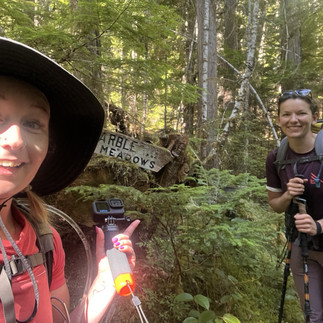
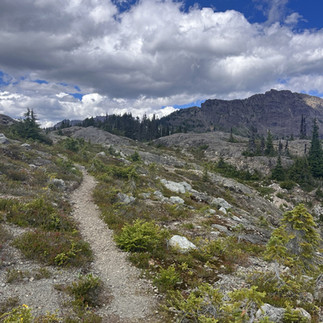
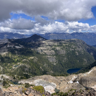
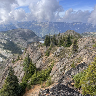
Starting out you pass the marine campsite and it's quite lovely with the Phillips creek mouth right there going into Buttle lake. Theres even picnic tables and we could see why some people would camp here and then hike in the AM. The first 4 hours of hiking with our packs was honestly a grind. You don't see much other then a cool lookout then water at the 2 mile mark. We filled up here and it was quite the swamp of a tarn - don't recommend going down there. Just fill up in the little creek. The bugs were crazy for sure but that's what you get being outdoors sometimes. I had felt a little dizzy as it was pretty hot and I really needed something to boost my sugar levels. So I got a fruit bar, a protein bar and was good to go. I have never felt like that on a hike and it scared me a little.Once my food had settled I was feeling good. I think because it was so hot out and it really does shine through those trees. We stopped a few times, only short ones and finally made our way to the first lookout of what we just climbed. I am thankful for 3L of water, as I definitely drank that much going up those switchbacks. It's about 2PM nearly and we start heading through the meadows. Passing every rock, tarn and beautiful lakes such as Limestone, Marsh Marigold, Globe Flower, Marblerock to finally Wheaton lake. This trail system is neat because you can make it different heading there and back. We chose to stay on the left hand side of Globe Flower and Marblerock and on the way back we did the opposite. You can see more of the area by doing this.


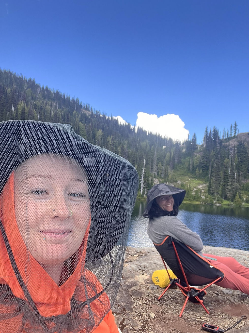
We knew we wanted a good advantage for Mcbride the next day, so we figured Wheaton Lake would be a good in-between. If I ever go back we both agreed we would push to the waterfalls near the ridge to go up Mcbride & Spire. You pass the hut which is super cool, the hut was built in 1970 by some students in memory of Will Wheaton - a student who died in a a climbing accident. Wheaton Lake is beautiful it was the Friday of the long weekend and not many people came up this day. We got a prime spot on the rocky bit of the lake. Some just camp right when you get down on this grassy bit which looks nice too but we decided to hike around and find a better spot. There was only 2 other girls in this area and we were all alone which was nice. We set up camp, did some swimming - which the water was the perfect tempature and ate some food. I climbed up a little peak in the area and had a dance party while Natasha read and had some down time. It had been a long day as we didn't get here until 3:30PM. We did 6 hours of hiking, so we were pretty exhausted. I made sure to stretch and set our alarms for 7AM as we had a big day the next day.


DAY 2: WHEATON LAKE TO MCBRIDE, MORRISON SPIRE & LOOP BACK
(approx 21+KMS + 1500M+ elevation -I'm guessing correct if wrong)
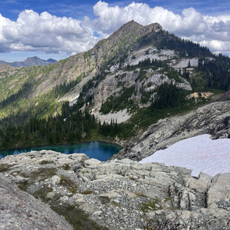
We woke up at 6:30AM before our alarms. I didn't have the greatest sleep as I forgot my toiletry bag that had my earplugs and etc. However I am in the mountains and it doesn't really matter. We are going to have a great day, it's beautiful and the mornings crispness was so good. This night we left our flys from our tents off and the stars were UNREAL. It was pretty cold at night in August. We got ready and had our oatmeal and set off. This hike is so stunning and we felt we couldn't stop taking pictures every 2 minutes. The landscape is beautiful, it makes up of so many different rock including granite, limestone, fossils and so many wild flowers. We left our camp, I should mention around 8AM. We passed the waterfalls, which I have seen a-lot of others photos and really pictures just dont do this place justice. You have to see with it with your own eyes. This area is where we would camp next time. The water is flowing fresh and there was several people set up here. We meandered our way up through tarns, rock and gained elevation to access the ridge line to plateau to start heading to our first objective Mount Mcbride. This mountain is most people's objective while coming up here.


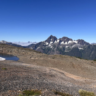
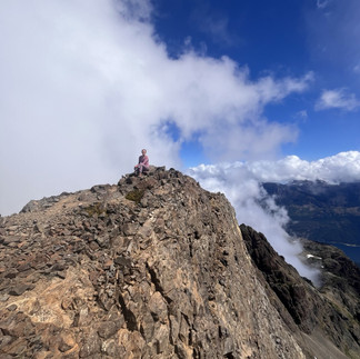
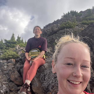
When we got up the ridge you could see my favourite mountain the Golden Hinde, having completed the Golden Hinde Traverse back in 2023, it was cool to connect Marble Meadows. I could see my other objectives such as Elkhorn completed back in 2022, I could see Mt. Septimus, Big Interior, Mount Albert Edward (which was also cool as we did the Augerpoint Traverse last year in 2024) really just admiring the Strathcona Park. I was already planning our next objective for 2026 up here LOL. Mcbride is a beast and from what I have read everyone said "it was further than we thought" I'm here to say that is true, it's long and you think your at the top until your not. It's the mountain that keeps on giving. This is a fucking mountain! It's exposure is WILD, it's not necessarily a hard climb or techincal but it will get your heart pumping. It's the 7th tallest peak on the island. Standing on the summit, it's so crazy how much it can just drop off. I was for sure getting a bit of vertigo standing on some areas! We didn't stay to long as we wanted to continue to Morrsion Spire. The junction back to meadows leaves you at a prime spot to achieve it in the same day. It's elevation is quite low as well. You can see the summit from the junction. We chose to loop around the spire to link back up where the waterfalls are. To make this a little different from the way we came up the ridge. It was a cool way to do it because not many people go this way and I had my GAIA to figure out that route. Morrison spire is chill and not as crazy as Mcbride. It was all right there, we signed two summit registers this day. The one on the spire could be replaced as everything in it was a soggy mess.


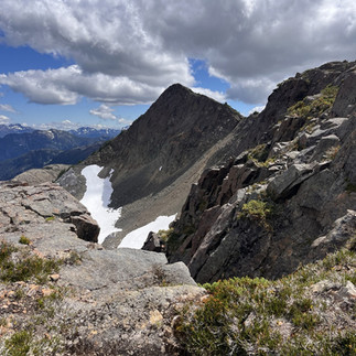
I honestly didn't take any photos during the drop form spire into the bowl and out around to the waterfalls as my anxiety was going just a tad. There was very few signs of life out there and I was focusing on finding the best route. When I'm leading my wolf pack, I get into the zone. We popped back out to where we came from and it was such a cool way looking back once my nerves were at rest. We seen so many cool rock formations, big tarns and this would have been the route veering off to head to Limestone Cap, Tibetan, Crystal, Mount Judy and you could bush whack down to Schjelderup to complete the Hinde. We made it to the waterfalls around 4:30PM and started making our way back to camp Wheaton Lake. We arrived around 6PM? We clocked 10 hours of hiking anyways and we were so ready for relaxation. I swam while Natasha sat in her camp chair. There was more people at the lake on the Saturday once we arrived. Which was kind of comedy listening to this big group of young guys. We made our food and made the decision to hike up and do Marble Peak the next day before heading back down. We got into our tents and doozed off. I will say the bugs were pretty bad but not the worst. We had bug nets which really helped.


DAY 3: WHEATON LAKE TO MARBLE PEAK, TO TRAILHEAD AND CROSSING BUTTLE LAKE
(approx. 12KMS+ 1500M elevation loss with 400M gain?) We didn't track so it's a guess)
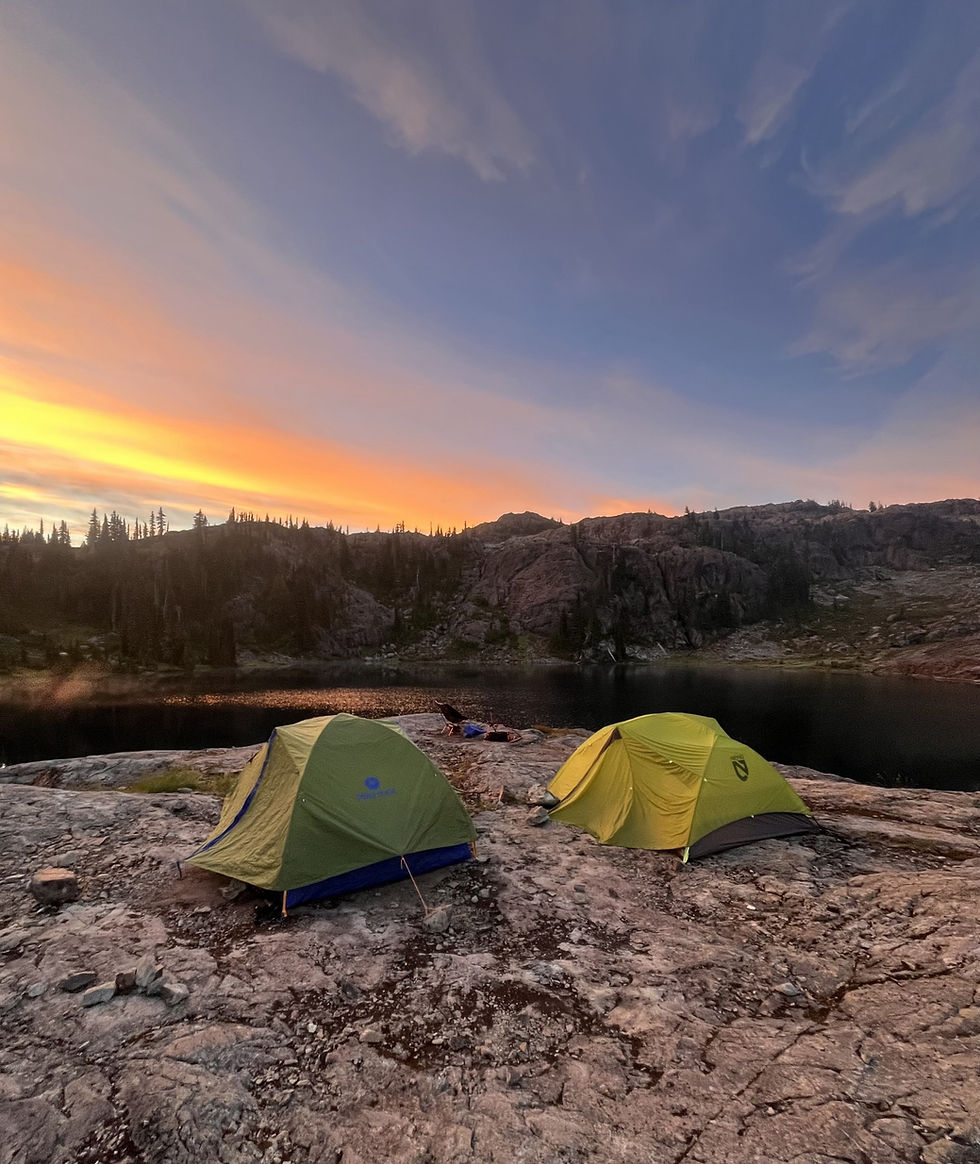
Natasha was all ready packing up at 5:45AM or something crazy, it didn't take me long to get up and do the same. We watched the most amazing sunrise from camp. The colours were so beautiful and yet everyone else there was sleeping missing it. The morning was dewey and left our tents wet for sure. We said goodbye to our lovely home for two nights and away we went to do as much as marble peak as we felt comfortable with. We went around Marblerock lake on the opposite side this time and a-lot of people camp there. It's really beautiful as well. Alltrails comments and map read not everyone makes it to the top of Marble Peak for being exposed. So we thought why the hell not do it? We are crazy! YEEHAW. We got up the first exposed wall it described, some mid 4 class moves for sure but nothing to crazy, to this chimney which was really fun then we got up the rock divide which was a scary but fun move then to the 2 foot jump gap to a flat rock wall and that was it for us. I now realize we could have pivoted and skirted around but honestly we were right there and comfortable. We both decided this was our limit and we will stay within it. Plus for a few more metres the view would have been the same. I don't need to risk anything just for the sake of saying I made it to the top like some people do. Plus we had gotten 2 other summits the day before LOL. I liked the views up here, you could see all the lakes from a different perspective and it was a nice bonus. I wouldn't say I would have been super excited if we had only done Marble Peak for this weekend as Mcbride most definitely takes the cake for this weekend.


We started to make our way back through Marsh Marigold Lake to Limestome and back into the trees we went. My legs were basically on fire from a sunburn but otherwise I was feeling pretty good as I streched the night before. I forgot advil because of forgetting some stuff in Natasha's truck. Next time, I survived anyways. I'm proud of my body this trip, we pushed them for sure and completing all 3 mountains was crazy cool. We pretty much did most of what you can do here, although in the mountains it's always endless. We arrived back to the marine campsite around 1:30PM? I want to say, I didn't take any photos on the way down. I was in the zone and taking lots of videos instead for my VLOG. I believe it took us 3 hours to get down, with minimal breaks with our heavy packs on. We were cruising but still going at a nice pace where it wasn't a race. We ran into a guy his name is Johnathan and he got up from the trailhead to Mcbride in 4 hours basically. I was impressed, there's always someone crazier than you out there.

Crossing Buttle lake it was 2PM once we loaded and got everything back into the tin boat. It was the afternoon and windy AF. It was actually scary how windy it was. We rolled the dice and went for it. We tried to go out once and the wind pushed us back in before being able to start the electric motor. So we hiked the boat up a little bit so it would push us towards our target - Augerpoint day use area that is 1KM away. I have grown up on boats to put this into perspective - the waves were huge and I thought not to be dramatic, we were going to flip IN A TIN BOAT. I can't imagine being in a kayak at this point, we saw a canoe and they were pratically at Myra falls LOL! I can see why people wait, I'm sure some of the people who weren't far off from the the trailhead must have either camped overnight there or waited until the evening because that was SKETCH. We made it over (somehow) two girls, one boat and a paddle if anything went wrong. Great, the eletric motor did it's thing and I kid you not it died as soon as we hit land. The wind veered us off course a bit and Natasha walked it over to where we needed to be as I waddled on shore without shoes. If Marble Peak wasn't enough of an adrenline rush this day, this absolutely did it. We hauled this thing back up to her truck with the strength we somehow did not have and made our way to enjoy a well deserved beer at Beach Fire Brewing in Campbell River. It was another 6 hour day and we still had to drive to Nanaimo. I came home unpacked, showered and started downloading all my videos from my GoPro, which will require more space on my iPhone. (time for a new phone) I woke up the next day (being today) and started writing this because my mind is fresh. It was a great adventure and one I will remember forever.
Thank you Natasha for being such an amazing hiking partner, we definitely missed Katie our other friend who was suppose to come but she will be with us next year for the next annual hike we do. I would like to give a shout out to my friend Natasha for pushing your limits at times but also keeping my nerves at ease and overall being the best company for three days. I really cherish these trips and I'm really happy we've found a good crew to tackle some of these bigger things together. You are amazing! Until next time.
I hope you all enjoyed this trip and you get out there, we are so lucky to live where we do. We live in paradise and it's never the same just by looking at these photos then actually being there. I have lots of other trips planned and why I needed to get this out as I have so many other hikes I will be writing about. See you all out there!
Watch the video version of this trip here.
LYSS X
Always remember to Leave No Trace, Pack in & Pack out & Be prepared!
Total approx. distance: 43KMS
Total approx elevation: 3,700M
Time: 3 days
Sore legs? Yes
Happy? 100%


This post really resonated with me, as I was in a completely different place before I started exploring the Marble Meadows circuit seriously. It’s fascinating to see how much more there is to unpack about this area, and I wholeheartedly agree that more people should experience it. Your detailed exploration of Mcbride, Morrison Spire, and Marble Peak is incredibly impressive; the depth you went into is truly commendable https://www.acma.gov.au/betstop-national-self-exclusion-registertm It makes me wonder how you validate what truly works in terms of experiencing these trails, especially for newcomers. For instance, I remember my first time trying to navigate some of the less-marked paths, and having this kind of guidance would have been invaluable. Your effort on this topic definitely doesn't…
This is precisely the kind of insightful content I love to share with friends! It's fascinating how much of my own experience with the Marble Meadows Circuit resonates with what you've described here. I recall my first hike there, feeling a similar sense of awe and wonder, and your detailed breakdown really captured that essence. It's also quite striking how the challenges and rewards you mentioned mirror my own journey through those trails; it felt like reading my own journal entries at times https://aana.com.au/self-regulation/codes-guidelines/wagering-code/ I was particularly impressed by how thoroughly you covered the nuances of the Marble Meadows area, offering a perspective that feels both deeply personal and universally relatable. It truly made me appreciate the whole experience even…
Considering Trekking Meaning explanations supports practical learning preparation. Information remains categorized clearly. Study follows consistent planning.
This post really resonated with me! I can absolutely relate to being in a completely different place before I started taking "marble meadows" seriously. It’s like a whole new perspective opened up. Your point about a marble meadows maturity model is brilliant; I could definitely see that being incredibly useful for guiding progress. The balance you've struck between depth and readability is just perfect, too. It's so accessible without sacrificing substance. Honestly, this write-up is exactly what I'll send when people ask me about marble meadows. It truly validates so much of what I've been thinking. The biggest challenge, though, is articulating the value of marble meadows to skeptics who haven't experienced it themselves. It's so rewarding once you're in…
This post on Marble Meadows really hit the nail on the head! I've been exploring some of these trails myself lately, and the balance you've struck between offering genuine, in-depth insights and keeping it accessible is truly impressive https://bots.ondiscord.xyz/lists/f_jgX6oKl It's not just a dry description; it feels like a conversation. Honestly, I'm already thinking about forwarding this to a friend who's been struggling with where to start their own adventures in the area https://payid.com.au/ The prioritization challenge you mentioned is incredibly real; trying to figure out what to tackle first can be overwhelming. It's a testament to your writing quality that you make these complex ideas so digestible. Someone definitely needed to articulate these points about the Marble Meadows circuit,…