Valley of Five Lakes in Jasper
- Alyssa Russell

- Nov 17, 2021
- 3 min read

In this Blog Series of Spotlights, I'm interviewing a fellow adventurer and friend Dallis. (@schlitz_13) I asked my friend to write about one of her favourite hikes to date, give it up for Dallis, it’s all you girl!
The Valley of Five Lakes, located in Jasper Alberta Canada. This hike is 8.8 kilometers, 140 meters elevation gain, and approximately 2.5 hours round trip. To preface, this was the only ‘real hike’ I did during my quick trip to Banff (Lake Louise) and Jasper in October of 2020. I also wasn’t and still am not in the best shape I could be in, so this was a bit of a workout for me. So, with that lets begin.

Driving south out of Jasper just a mere 9 kilometers, towards Banff and Lake Louise, you will come across a parking lot. Park here and this is where you begin your hike from the Icefields Parkway access point.
This hike begins with a nice gentle winding trail through the woods, which opens to a gentle slope down hill, and a bridge over Wabasso Creek.

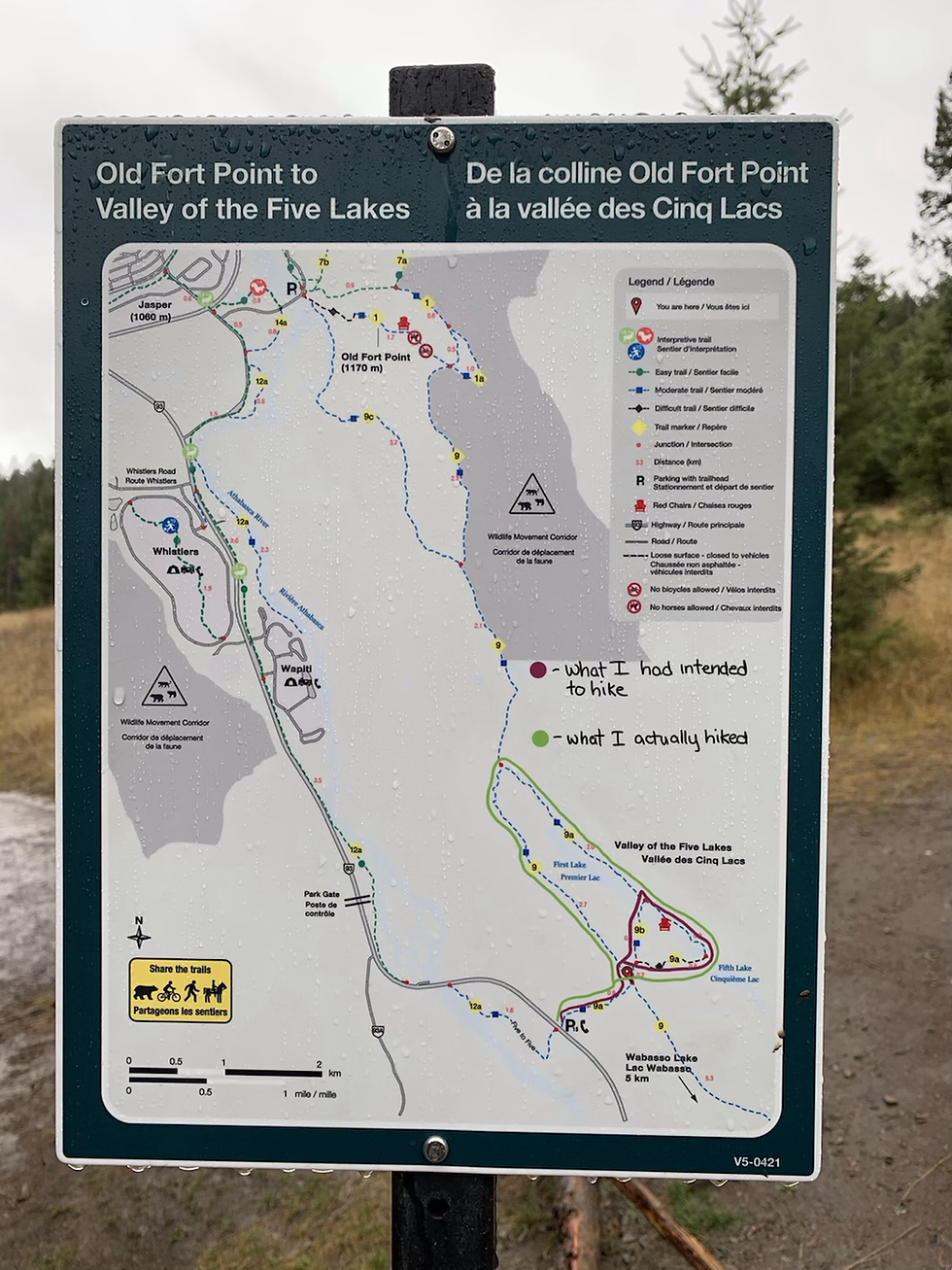
Here is where my truly adventure begins. Usually, this trail is only 4.7 kilometer’s, with approximately 66 meters in elevation gain, but as you read above, I almost doubled the distance. A mistake I made reading the map (posted below) I followed the trail to connect The Valley of Five Lakes to Old Fort Point Trail System, and at the end of the First of the Five Lakes, turned to go back along the backside of the lake, and eventually got to the usual loop that shows you the lakes in under 2 hours total.

When I was at the point to turn back to go towards the main loop, it was quite muddy, and very difficult to follow the trail, thank goodness for the AllTrails app as I would have had a much harder time finding my way back if I didn’t have that app with me. So make sure you dress accordingly, and have a well charged cellphone.

If you haven’t already downloaded AllTrails do so its an amazing resource of trails and the ability to use the map feature on it when your out on the trails. Once I got back to the ‘main loop’ it was a quick zip around the other four lakes, which let’s be honest were more of puddles then actual lakes (sorry but they were puddles) the first lake is the largest and even that is hardly a lake in my opinion. The loop around the first lake I took is where I added the accidental extra 4.1 kilometer’s and additional 0.5 or 1.0 hour of time. But it was a happy mistake, I had the best time hiking solo.

Along the way I ran into another couple who did the same thing I did, thinking they were on the correct trail, they were just the long way round. On the backside of the lake, I ran into a group of locals showing their Irish friend around he and I joked we brought the soggy weather with us, as I shared, I was from the Wet…I mean West Coast of British Columbia. Continued my way getting more and more soaked but happier all the while.

Eventually I got back to the main loop, which was the loop to be on, as there were families with small children, dogs and theirowners, and other tourists (Canadians as our borders were closed at the time due to the global pandemic). I also found the Parks Canada Red Chairs on this hike overlooking the second of the five lakes.

The loop around the first lake is where I lost and gained most of my elevation, during this hike, and after I had gone around the fifth lake, was where the remaining elevation, once out of the ‘valley’ I was back on the trail that I started the hike on, a nice wander back out to the parking lot. After I was done this I started my car up, changed my soaking wet clothing (after all this was in October of 2020.) and headed back to my hotel room. I still have many hikes, I would like to do here and I'm hoping to be back next year. Thanks so much for reading!
-Dallis (@schlitz_13)


Comments